Demo · research preview Upstream data layer · not another viewer
Who's drilling next to your ground — and what did they hit?
Draw an area on a map and answer three questions that take days to compile by hand: who holds the ground, what have they reported, and what is the drill data.
Compiled from public disclosures into model-ready files you can trust — and export straight into Leapfrog, QGIS or Micromine.
Today this is a guided demo: request an area and we compile it semi-automatically — a dashboard plus downloadable, model-ready files — usually within 24 hours.
Personally invited — we reply with your area and a private demo link, usually within 24 hours.
How it works
One gesture. Three answers. Model-ready out.
The same data that takes days to assemble by hand — compiled and verified for you, traceable to its source document on every number.
Draw or name an area
Lasso the ground you care about, or just name a company. GeoLasso resolves the tenure holders — including subsidiaries the register hides behind other names.
See what was reported
Recent ASX drilling fused with historical open-data geochem, collar boreholes and granted mining leases — on one map, in 2D and 3D. A time slider scrubs decades of drilling: where activity moved, and which ground was drilled then walked away from — your second-look targets.
Export model-ready
Collar, survey and assay in one structured file. A working CSV / GeoPackage export, straight into Leapfrog, QGIS or Micromine.
A look inside
What lands in your inbox
Here's what those three steps actually produce: an audited dashboard for your area, in 2D and 3D, with model-ready files to download.
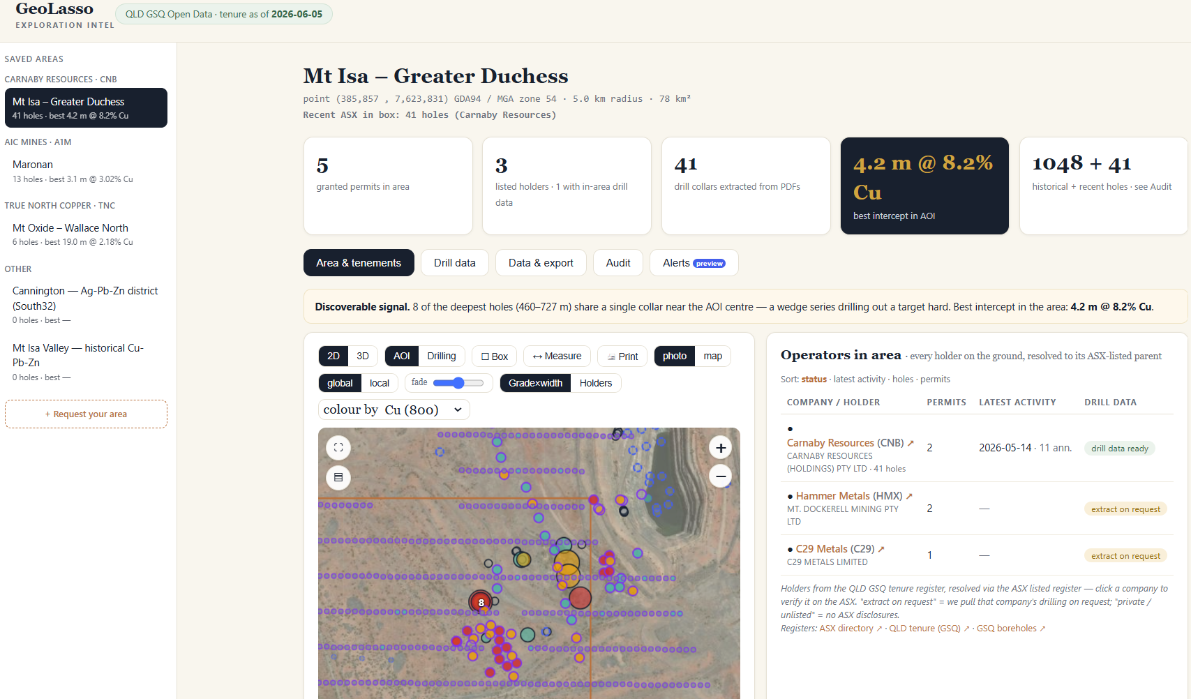
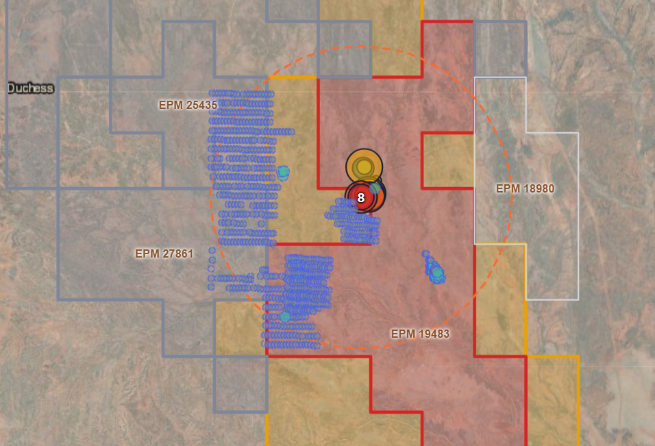
The fused map viewRecent ASX drilling, historical geochem and granted tenure on one map. Pick the element — Cu / Au / Ag / Pb / Zn — or colour by grade×width, then draw a box to filter the holes, table and KPIs to your ground.
Holes in 3D — real open data762 historical holes from a public QLD GSQ open-file report (MDL 85, Trekelano), coloured by copper grade — auto-rotating; drag to orbit, scroll to zoom. Open data (CC-BY); the live demo adds the recent ASX layer (gated). Board- and investor-ready.
What's what here: the dashboard & tables are screenshots of the real Mt Isa demo; the download and the 3D are real open data (QLD GSQ, CC-BY). Your delivered demo adds the recent ASX layer and is built from real compiled data for your area.
Go deeper — for evaluatorsThe drill data, the audit & the export Show +Hide -

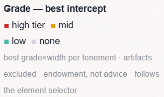
Downhole interceptsAssay intervals at true downhole depth, holes sorted by best Cu grade — the strip log follows the element you pick.
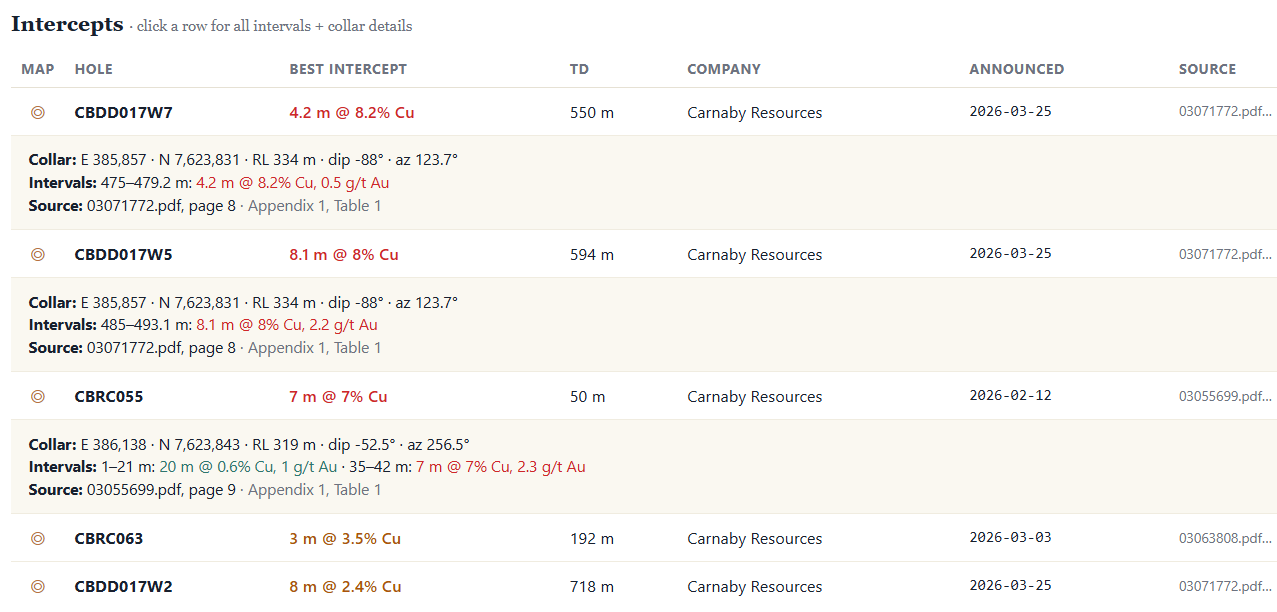
Model-ready interceptsEvery hole with its collar, intervals and the source PDF + page. One click exports CSV / GeoPackage for Leapfrog.
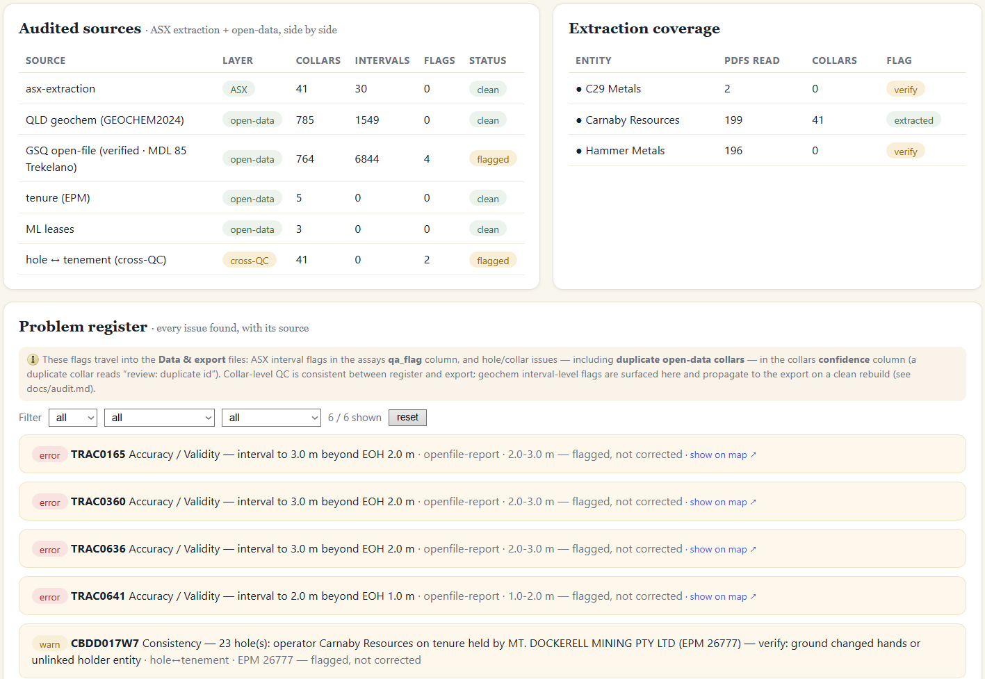
The audit & problem registerSources side by side (ASX + open data), extraction coverage, and every issue flagged — never silently corrected. Each problem names its source and shows on the map. Trust you can stand behind.
The gap · why a paid product from public dataLegally public. Practically invisible. Show +Hide -
A company does not have its neighbours' ASX drill results sitting in Leapfrog. They are scattered across thousands of unstructured PDFs — never geo-located, never in any GIS. Getting them means days of work per neighbour that nobody does systematically. GeoLasso sells the compilation, not exclusivity — the way Bloomberg sells structure and timeliness over public market data.
Already in your model
The client's own drilling, already in Leapfrog. A viewer adds nothing.
No valueThe neighbour's IP
Undisclosed drilling under live tenure. We hold that line for everyone — which is exactly why a client trusts us with their own ground.
NeverThe product
Every neighbour's ASX-disclosed drilling, open-file & relinquished GSQ reports, bulk geochem — compiled, structured, geo-located, audited.
This is what we sellWho it's for
Built for the model — not the feed
The same compiled, verified neighbour-drilling layer serves two buyers — for two different jobs. A geologist puts it under a model; an investor reads it as signal. Both get the trust spine a raw feed can't offer.
A model-ready drillhole dataset
The job: collars · surveys · assays into Leapfrog — with zero cleanup.
Compile the available public drilling in and around your ground — plus the neighbours' latest ASX results — structured, geo-located and export-ready. Not documents to read, not a market lens: the dataset you model on.
- Drill planning & due diligence on new ground or a farm-in
- Target generation — the "second look" on abandoned ground
- Regional context for a JORC report or capital raise
Verified drilling intelligence
Cut through announcement hype: every intercept on the map and linked to the exact page, so a valuation or due-diligence call rests on the document — not the headline. The same provenance and audit a geologist demands.
Next: personally configurable dashboards per client. Today: two focused lanes, one verified data layer underneath.
The sharpest use caseThe second look — targets on abandoned ground Show +Hide -
Find targets on ground other people walked away from. Relinquished tenure open-files fast — so the old record is densest exactly where companies gave up. Fuse it with the neighbours' fresh ASX results on one timeline, and see where yesterday's "no" should be today's "yes".
Relinquished & historical drilling, open-file geochem, dated by drill date — with who walked away, and when.
Recent ASX-disclosed intercepts on neighbouring ground. Mineralisation ignores tenement boundaries.
Ground drilled and abandoned, now sitting next to fresh, better results. Scrub the time slider and watch the re-rating.
In the demo
Five fused areas across the Mt Isa copper-gold district
A working proof-of-concept across NW Queensland, verified end-to-end on live-synced tenure. The flagship — Mt Isa – Greater Duchess (Carnaby, ASX:CNB) — is the richest set.
The proving groundSee the five demo areas Show +Hide -
Areas: Mt Isa (Carnaby) · Maronan (Maronan Metals + AIC — "extract on request", proven) · Mt Oxide (True North Copper) · Cannington (South32 ground) · Mt Isa Valley (Mount Isa Mines). Each fuses recent ASX drilling with open-data geochem, collar boreholes and granted mining leases under one identity — Cu/Au/Ag/Pb/Zn selector, audit view, source provenance and a working export.
The trust mechanism
Not a claim — the document.
Each delivered record is structured, model-ready and linked to its available source. One click opens the ASX announcement at the exact page. That auditability is the whole point of an upstream layer you'd put under your own model.
Source provenance on every number
Each intercept links back to the disclosure it came from — the announcement, the page, the hole id.
A reconciled completeness ledger
We report the gap, not just the data: found N of M announcements, extracted H of H′ JORC collar rows. A raw feed can't tell you what it's missing — we can.
A 6-dimension data-quality audit
Completeness, validity, tenure QC and hole↔tenement cross-checks — recomputed from each bundle's own data, so the audit and the export stay consistent by construction.
Name resolution you don't have to do
The register says "Mt Dockerell" — but that's Hammer's subsidiary. GeoLasso resolves it to the listed parent, with the source and a confidence flag.
4.2 m @ 8.2% Cu
Source-verified to the per-wedge hole id.
One click opens the announcement at the exact page — inside the demo.
≥95% of ASX-disclosed holes in your area. Drilling that is never disclosed hole-by-hole is a ceiling nobody crosses — and we say so. Stating the limit is what earns the trust.
ASX source PDFs sit behind the demo's access gate, but the same provenance runs on open data you can open right now: a real QLD open-file borehole report, and a model-ready sample built from it.
Open a public source report ↗ · Download the open-data collars CSV
What we offer
A demo today — a live platform next
GeoLasso is a working prototype, proven end-to-end on the Mt Isa district. Right now it runs as a guided, done-for-you demo so you can see the data layer on your own ground before anything is built as a product.
Request an area, we build it
You draw or name an area; we compile it semi-automatically from real public data and send you a personal result — usually within 24 hours.
- An interactive dashboard for your area (2D + 3D, audit, provenance)
- Downloadable, model-ready files — CSV & GeoPackage for Leapfrog / QGIS / Micromine
- A QC / completeness note so you can trust every number
- Delivered done-for-you — no account, no setup
- On request: a weekly watch on your area — tenure coming free now, plus new neighbour drilling
Self-serve, near-real-time
The same engine, opened up: draw any area and get results back almost instantly, kept fresh and personalised.
- Near-real-time queries across all of ASX — any area you draw
- Personally configurable dashboards per company
- Automated, near-real-time monitoring & alerts (self-serve)
- The verified historical (open-file) premium layer on a toggle
Try it now
Draw or name your ground
Drop a box on the map — or just type a company, tenement or place name. We compile that area semi-automatically from real public data and email you a personal demo: the dashboard plus model-ready files, usually within 24 hours.